
L Jetty Surf Guide
L Jetty in New Jersey is an exposed beach/Jetty break that has reasonably consistent surf and can work at any time of the year. The best wind direction is from the west. Waves just as likely from local windswells as from distant groundswells and the optimum swell angle is from the east southeast. The beach break offers mainly right hand waves. Best around low tide when the tide is rising. It's often crowded here. Take care of rocks in the line up.
L Jetty Spot Info
| Type: | Rating: | Reliability: | Todays Sea Temp*: |
|---|---|---|---|
| fairly consistent | 17.9°C*ocean temperature recorded from satellite |
Surfing L Jetty:
The best conditions reported for surf at L Jetty occur when a East-southeast swell combines with an offshore wind direction from the West.
What's the best time of year to surf L Jetty (for consistent clean waves)?
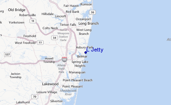
Explore L Jetty Location Map
Interactive L Jetty surf break location map. View information about nearby surf breaks, their wave consistency and rating compared to other spots in the region. Current swell conditions from local buoys are shown along with live wind speed and direction from nearby weather stations. Click icons on the map for more detail. The closest passenger airport to L Jetty is Lakehurst Naes Airport (NEL) in USA, 35 km (22 miles) away (directly). The second nearest airport to L Jetty is John F Kennedy International (New York) Airport (JFK), also in USA, 53 km (33 miles) away.
- Map Icons:
 Break
Break Live Wave Height (m)
 Live Wind Speed (km/h)
 Surf Rating (10 Max)
 Ocean Swells (m)
- Wind Speed (km/h)
Tuesday, 9 June 2026, 05:34 Local Time
| Tuesday 09 | ||||
| 5AM | 8AM | 11AM | 2PM | |
| Wave (m) | ||||
| Period (s) | 6 | 6 | 5 | 8 |
| Wind (km/h) | ||||
| Wind State | cross- off |
cross- off |
cross- off |
cross |
Tides at L Jetty
| NEXT | IS AT (local time) | remaining |
|---|---|---|
| high tide | ||
| low tide |
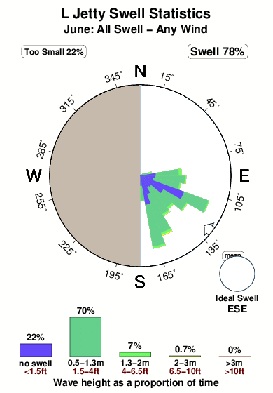
Swell History at L Jetty
Surf stats for L Jetty, see the swell variation by month or season on the history page here.

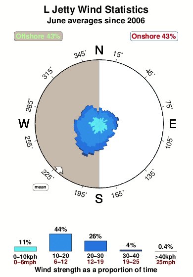
Wind History at L Jetty
Wind stats for L Jetty, see the variation in direction and stength by month or season on the history page here.
Other Nearby Breaks Closest To:
Discover surf breaks near L Jetty. Click below to view there surf guides.
 Nearest