

Jenkinsons (Point Pleasant Beach) Surf Guide
Jenkinsons (Point Pleasant) in New Jersey is an exposed beach/Jetty break that has reasonably consistent surf and can work at any time of the year. Works best in offshore winds from the west. Tends to receive a mix of groundswells and windswells and the optimum swell angle is from the east northeast. The beach break favours left handers. Best around low tide. When the surf is up, crowds are likely Hazards include rips and rocks.
Jenkinsons (Point Pleasant Beach) Spot Info
| Type: | Rating: | Reliability: | Todays Sea Temp*: |
|---|---|---|---|
| fairly consistent | 17.6°C*ocean temperature recorded from satellite |
Surfing Jenkinsons (Point Pleasant Beach):
The best conditions reported for surf at Jenkinsons (Point Pleasant Beach) occur when a East-northeast swell combines with an offshore wind direction from the West.
What's the best time of year to surf Jenkinsons (Point Pleasant Beach) (for consistent clean waves)?
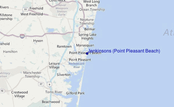
Explore Jenkinsons (Point Pleasant Beach) Location Map
Interactive Jenkinsons (Point Pleasant Beach) surf break location map. View information about nearby surf breaks, their wave consistency and rating compared to other spots in the region. Current swell conditions from local buoys are shown along with live wind speed and direction from nearby weather stations. Click icons on the map for more detail. The closest passenger airport to Jenkinsons (Point Pleasant Beach) is Lakehurst Naes Airport (NEL) in USA, 28 km (17 miles) away (directly). The second nearest airport to Jenkinsons (Point Pleasant Beach) is Mc Guire Afb (Wrightstown) Airport (WRI), also in USA, 48 km (30 miles) away.
- Map Icons:
 Break
Break Live Wave Height (m)
 Live Wind Speed (km/h)
 Surf Rating (10 Max)
 Ocean Swells (m)
- Wind Speed (km/h)
Tuesday, 9 June 2026, 08:11 Local Time
| Tuesday 09 | ||||
| 5AM | 8AM | 11AM | 2PM | |
| Wave (m) | ||||
| Period (s) | 6 | 6 | 5 | 3 |
| Wind (km/h) | ||||
| Wind State | cross- off |
cross- off |
cross- off |
cross |
Tides at Jenkinsons (Point Pleasant Beach)
| NEXT | IS AT (local time) | remaining |
|---|---|---|
| high tide | ||
| low tide |
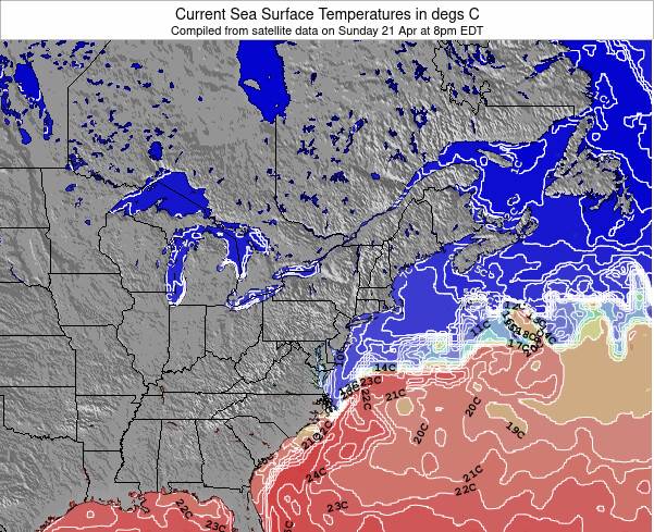
Jenkinsons (Point Pleasant Beach) Sea Temperature
Sunny with pleasantly warm air temperatures (feeling like 20.0 °C once we account for wind), yet at 17.6 °C the sea remains several degrees colder than the air at Jenkinsons (Point Pleasant Beach). The majority of surfers will need a spring wetsuit though a summer suit or even a shorty may suffice for a short session.
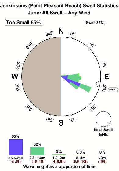
Swell History at Jenkinsons (Point Pleasant Beach)
Surf stats for Jenkinsons (Point Pleasant Beach), see the swell variation by month or season on the history page here.

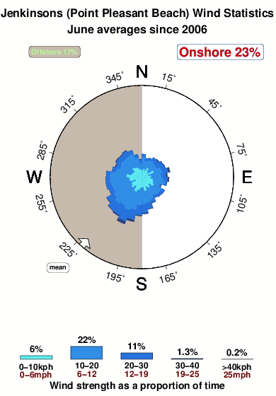
Wind History at Jenkinsons (Point Pleasant Beach)
Wind stats for Jenkinsons (Point Pleasant Beach), see the variation in direction and stength by month or season on the history page here.
Jenkinsons (Point Pleasant Beach) Reviews:
Interactive Porthcawl Point location map. View nearby buoy information, live wind conditions and surrounding roads, paths and locations to help find new breaks. Click the buoys or wind icon to view more information.
- Overall:
 2.0
2.0 - Quality on a good day:2.0
- Consistency of Surf:
 3.0
3.0 - Difficulty Level:
 4.0
4.0 - Crowds:2.0
Other Nearby Breaks Closest To:
Discover surf breaks near Jenkinsons (Point Pleasant Beach). Click below to view there surf guides.
 Nearest