
Jelly's Point Surf Guide
Jelly's Point in Surigao Del Sur Province is an exposed point break that has reasonably consistent surf, although summer tends to be mostly flat. Works best in offshore winds from the southwest. Windswells are much more common than groundswells and the best wave direction is from the northeast. Best around low tide when the tide is rising. It very rarely gets crowded here. Beware of rocks and urchins.
Jelly's Point Spot Info
| Type: | Rating: | Reliability: | Todays Sea Temp*: |
|---|---|---|---|
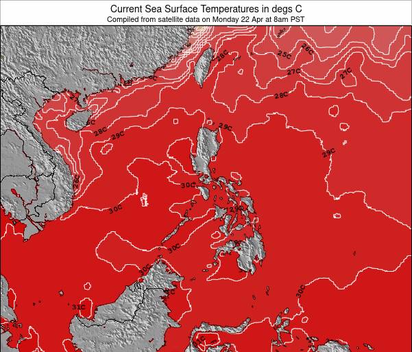
| fairly consistent | 30.4°C*ocean temperature recorded from satellite |
Surfing Jelly's Point:
The best conditions reported for surf at Jelly's Point occur when a Northeast swell combines with an offshore wind direction from the Southwest.
What's the best time of year to surf Jelly's Point (for consistent clean waves)?
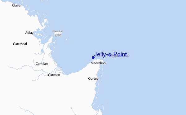
Explore Jelly's Point Location Map
Interactive Jelly's Point surf break location map. View information about nearby surf breaks, their wave consistency and rating compared to other spots in the region. Current swell conditions from local buoys are shown along with live wind speed and direction from nearby weather stations. Click icons on the map for more detail. The nearest passenger airport to Jelly's Point is Cagayan De Oro (Ladag) Airport (CGY) in Philippines, which is 198 km (123 miles) away (directly). The second closest airport to Jelly's Point is Daniel Z Romualdez (Tacloban) Airport (TAC), also in Philippines, 247 km (153 miles) away.
- Map Icons:
 Break
Break Live Wave Height (m)
 Live Wind Speed (km/h)
 Surf Rating (10 Max)
 Ocean Swells (m)
- Wind Speed (km/h)
Tuesday, 9 June 2026, 11:38 Local Time
| Tuesday 09 | ||||
| 11AM | 2PM | 5PM | 8PM | |
| Wave (m) | ||||
| Period (s) | 12 | 12 | 12 | 12 |
| Wind (km/h) | ||||
| Wind State | cross- on |
cross- on |
cross | cross- off |
Tides at Jelly's Point
| NEXT | IS AT (local time) | remaining |
|---|---|---|
| high tide | ||
| low tide |
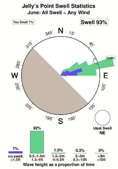
Swell History at Jelly's Point
Surf stats for Jelly's Point, see the swell variation by month or season on the history page here.

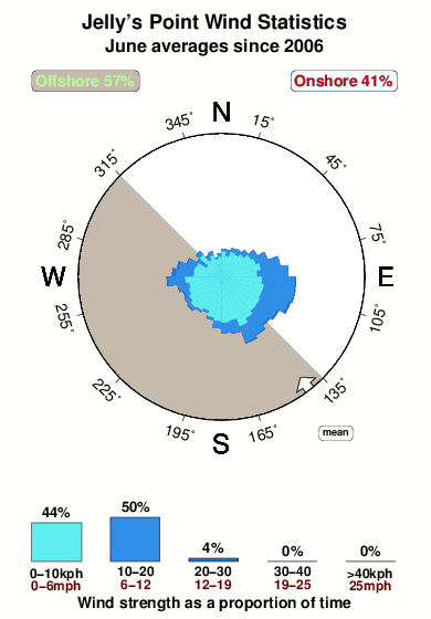
Wind History at Jelly's Point
Wind stats for Jelly's Point, see the variation in direction and stength by month or season on the history page here.
Other Nearby Breaks Closest To:
Discover surf breaks near Jelly's Point. Click below to view there surf guides.
 Nearest