

Hermosa Beach and Pier Surf Guide
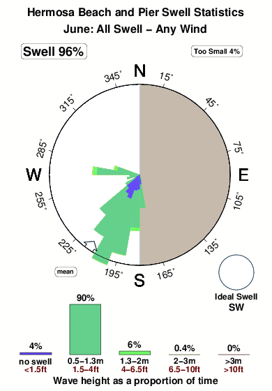
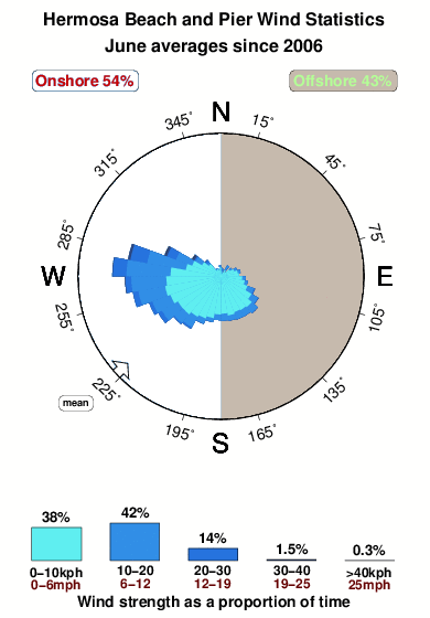
Hermosa Beach and Pier in LA County is an exposed beach break that has fairly consistent surf. Summer offers the optimum conditions for surfing. Offshore winds are from the east. Tends to receive distant groundswells and the optimum swell angle is from the southwest. The beach break provides left and right handers. Best around mid tide when the tide is rising. It's often crowded here. Take care of rips and pollution.
Hermosa Beach and Pier Spot Info
| Type: | Rating: | Reliability: | Todays Sea Temp*: |
|---|---|---|---|
| fairly consistent | 18.4°C*ocean temperature recorded from satellite |
Surfing Hermosa Beach and Pier:
The best conditions reported for surf at Hermosa Beach and Pier occur when a Southwest swell combines with an offshore wind direction from the East.
What's the best time of year to surf Hermosa Beach and Pier (for consistent clean waves)?
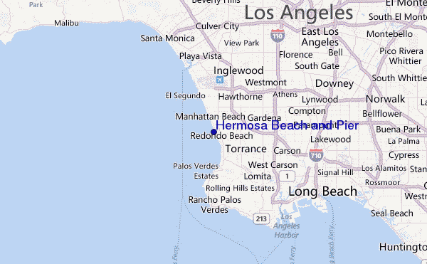
Explore Hermosa Beach and Pier Location Map
Interactive Hermosa Beach and Pier surf break location map. View information about nearby surf breaks, their wave consistency and rating compared to other spots in the region. Current swell conditions from local buoys are shown along with live wind speed and direction from nearby weather stations. Click icons on the map for more detail. The closest passenger airport to Hermosa Beach and Pier is Jack Northrop Fld Hawthorne Muni Airport (HHR) in USA, 9 km (6 miles) away (directly). The second nearest airport to Hermosa Beach and Pier is Los Angeles International Airport (LAX), also in USA, 9 km (6 miles) away.
- Map Icons:
 Break
Break Live Wave Height (m)
 Live Wind Speed (km/h)
 Surf Rating (10 Max)
 Ocean Swells (m)
- Wind Speed (km/h)
Tuesday, 9 June 2026, 02:45 Local Time
| Tuesday 09 | ||||
| 2AM | 5AM | 8AM | 11AM | |
| Wave (m) | ||||
| Period (s) | 20 | 20 | 19 | 19 |
| Wind (km/h) | ||||
| Wind State | cross- off |
glass | glass | cross- on |
Tides at Hermosa Beach and Pier
| NEXT | IS AT (local time) | remaining |
|---|---|---|
| high tide | ||
| low tide |
Hermosa Beach and Pier Sea Temperature
The water temperature (18.4 °C) at Hermosa Beach and Pier is relatively warm. If the sun does come out as forecast, it should feel warm enough to surf in a summer wetsuit. Effective air temperature of 19.0 °C.

Swell History at Hermosa Beach and Pier
Surf stats for Hermosa Beach and Pier, see the swell variation by month or season on the history page here.

Wind History at Hermosa Beach and Pier
Wind stats for Hermosa Beach and Pier, see the variation in direction and stength by month or season on the history page here.
Other Nearby Breaks Closest To:
Discover surf breaks near Hermosa Beach and Pier. Click below to view there surf guides.
- Redondo - The Breakwater
 Breakwater
 3.0
3.0
Reliability: fairly consistent2km away - Manhattan 26th street
- Beach
 2.0
2.0
Reliability: fairly consistent3km away - Topaz Street
- Beach/jetty
- 2.0
Reliability: fairly consistent3km away - Manhattan Beach and Pier
- Beach
 1.0
1.0
Reliability: consistent4km away - Redondo Beach
- Beach
- 1.0
Reliability: very consistent4km away
 Nearest