
Hazard Canyon Surf Guide
Hazard Canyon in San Luis Obispo is an exposed reef break that has pretty consitent surf. Winter is the optimum time of year for surfing here. The best wind direction is from the southeast. Groundswells more frequent than windswells and the ideal swell direction is from the northwest. Primarily a right hand reef break, although a left is also possible.. Best around mid tide. It's sometimes crowded here. Hazards include rips, rocks, locals and sharks.
Hazard Canyon Spot Info
| Type: | Rating: | Reliability: | Todays Sea Temp*: |
|---|---|---|---|
| fairly consistent | 12.6°C*ocean temperature recorded from satellite |
Surfing Hazard Canyon:
The best conditions reported for surf at Hazard Canyon occur when a Northwest swell combines with an offshore wind direction from the Southeast.
What's the best time of year to surf Hazard Canyon (for consistent clean waves)?
Explore Hazard Canyon Location Map
Interactive Hazard Canyon surf break location map. View information about nearby surf breaks, their wave consistency and rating compared to other spots in the region. Current swell conditions from local buoys are shown along with live wind speed and direction from nearby weather stations. Click icons on the map for more detail. The closest passenger airport to Hazard Canyon is Vandenberg Afb (Lompoc) Airport (VBG) in USA, 68 km (42 miles) away (directly). The second nearest airport to Hazard Canyon is Lemoore Nas Airport (NLC), also in USA, 144 km (89 miles) away.
- Map Icons:
 Break
Break Live Wave Height (m)
 Live Wind Speed (km/h)
 Surf Rating (10 Max)
 Ocean Swells (m)
- Wind Speed (km/h)
Tuesday, 9 June 2026, 03:12 Local Time
| Tuesday 09 | ||||
| 2AM | 5AM | 8AM | 11AM | |
| Wave (m) | ||||
| Period (s) | 7 | 6 | 6 | 5 |
| Wind (km/h) | ||||
| Wind State | on | on | on | on |
Tides at Hazard Canyon
| NEXT | IS AT (local time) | remaining |
|---|---|---|
| high tide | ||
| low tide |

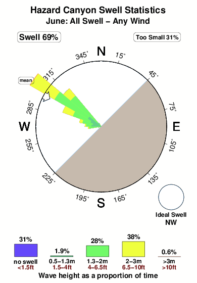
Swell History at Hazard Canyon
Surf stats for Hazard Canyon, see the swell variation by month or season on the history page here.

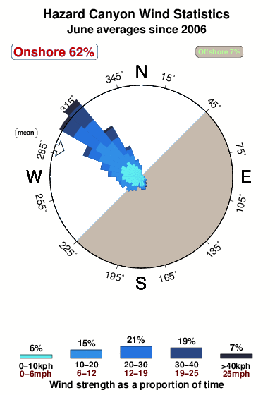
Wind History at Hazard Canyon
Wind stats for Hazard Canyon, see the variation in direction and stength by month or season on the history page here.
Other Nearby Breaks Closest To:
Discover surf breaks near Hazard Canyon. Click below to view there surf guides.
 Nearest