

- Forecast
- Maps
- Live
- Weather State
- Spot Information
4 Mile Surf Forecast
/ CAL – Santa Cruz (30 breaks) / California (404 breaks) /
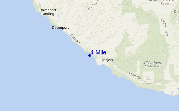
4 Mile surf Forecast / CAL – Santa Cruz / USA
- Map Icons:
 Break
Break Live Wave Height (m)
 Live Wind Speed (km/h)
 Surf Rating (10 Max)
 Ocean Swells (m)
- Wind Speed (km/h)
How big are the waves at 4 Mile today?
The current surf forecast for 4 Mile at 11AM is: 0.7m 16s primary swell from a South-southwest direction and 0.6m 10s secondary swell from a West-northwest direction, 0.2m 2s secondary swell from a South-southeast direction (forecast issued at 04:00am April 24). The wind direction is predicted to be cross-shore and the swell rating is 2.
| Time (PDT) & Date | Wave Height | Wave Period |
|---|---|---|
| Morning (24 Apr) | 2.5ft (0.7m) | 16s |
| Afternoon (24 Apr) | 2.5ft (0.7m) | 16s |
| Evening (24 Apr) | 2ft (0.6m) | 16s |
Table - waves today at 4 Mile. (Swell directed towards the surf break)
Wednesday 24 | Thursday 25 | Friday 26 | Saturday 27 | Sunday 28 | Monday 29 | Tuesday 30 | Wednesday 01 | |||||||||||||||||||||||||||||||||||||||||||||||||||||
| 2 AM | 5 AM | 8 AM | 11 AM | 2 PM | 5 PM | 8 PM | 11 PM | 2 AM | 5 AM | 8 AM | 11 AM | 2 PM | 5 PM | 8 PM | 11 PM | 2 AM | 5 AM | 8 AM | 11 AM | 2 PM | 5 PM | 8 PM | 11 PM | 2 AM | 5 AM | 8 AM | 11 AM | 2 PM | 5 PM | 8 PM | 11 PM | 2 AM | 5 AM | 8 AM | 11 AM | 2 PM | 5 PM | 8 PM | 11 PM | 2 AM | 5 AM | 8 AM | 11 AM | 2 PM | 5 PM | 8 PM | 11 PM | 2 AM | 5 AM | 8 AM | 11 AM | 2 PM | 5 PM | 8 PM | 11 PM | 2 AM | 5 AM | 8 AM | 11 AM | |
Rating (10 max) | ||||||||||||||||||||||||||||||||||||||||||||||||||||||||||||
Swell Height Map |    |    |    |    |  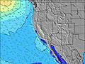 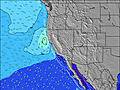 |  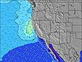 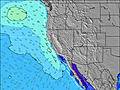 |  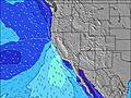 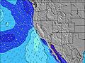 | 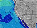 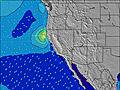 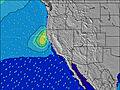 | ||||||||||||||||||||||||||||||||||||||||||||||||||||
| Wave Height (m) & direction (?) | ||||||||||||||||||||||||||||||||||||||||||||||||||||||||||||
| Period(s) (?) | 16 | 16 | 16 | 16 | 16 | 16 | 16 | 16 | 15 | 15 | 7 | 8 | 7 | 19 | 15 | 15 | 15 | 18 | 18 | 18 | 18 | 7 | 8 | 8 | 9 | 9 | 9 | 9 | 9 | 8 | 8 | 8 | 8 | 8 | 8 | 7 | 15 | 15 | 12 | 15 | 7 | 7 | 8 | 8 | 8 | 8 | 9 | 9 | 9 | 10 | 10 | 10 | 10 | 9 | 9 | 9 | 9 | 9 | 8 | 8 |
Wave (?)Graph | ||||||||||||||||||||||||||||||||||||||||||||||||||||||||||||
| Energy (?) | 234 | 226 | 223 | 220 | 223 | 284 | 166 | 164 | 186 | 158 | 230 | 178 | 160 | 106 | 106 | 106 | 106 | 124 | 209 | 209 | 270 | 298 | 389 | 675 | 730 | 1219 | 1126 | 1012 | 536 | 524 | 455 | 432 | 650 | 527 | 253 | 193 | 144 | 144 | 167 | 144 | 138 | 173 | 270 | 363 | 500 | 682 | 699 | 766 | 1358 | 816 | 832 | 849 | 833 | 903 | 846 | 749 | 865 | 783 | 613 | 280 |
Wind (km/h) | ||||||||||||||||||||||||||||||||||||||||||||||||||||||||||||
| Wind State (?) onshore cross-onshore cross-shore cross-offshore offshore glassy | cross- on | cross | cross- off | cross | on | on | cross | cross- off | cross | cross | cross | cross | cross | cross | cross | cross | cross | cross | cross | cross | cross | cross | cross | cross | cross | cross- off | cross- off | cross | cross | cross | cross | cross- off | cross- off | cross- off | cross | cross | cross | cross | cross | cross- off | cross- off | cross- off | cross- off | cross | cross | cross | cross- off | cross- off | cross- off | cross- off | cross- off | cross | cross | cross | cross- off | cross- off | cross- off | cross- off | cross | cross |
High Tide / height (m) | 12:16PM 1.61 | 11:11PM 2.07 | 1:08PM 1.56 | 11:39PM 2.08 | 2:05PM 1.50 | 12:10AM 2.06 | 3:14PM 1.47 | 12:48AM 2.03 | 4:36PM 1.47 | 1:35AM 1.99 | 5:52PM 1.51 | 2:37AM 1.93 | 6:38PM 1.58 | 3:54AM 1.86 | ||||||||||||||||||||||||||||||||||||||||||||||
Low Tide / height (m) | 5:46AM 0.38 | 5:07PM 1.10 | 6:25AM 0.33 | 5:33PM 1.20 | 7:07AM 0.32 | 6:00PM 1.29 | 7:55AM 0.32 | 6:29PM 1.36 | 8:48AM 0.34 | 7:10PM 1.42 | 9:47AM 0.35 | 8:29PM 1.46 | 10:48AM 0.36 | 10:22PM 1.45 | ||||||||||||||||||||||||||||||||||||||||||||||
Wednesday 24 | Thursday 25 | Friday 26 | Saturday 27 | Sunday 28 | Monday 29 | Tuesday 30 | Wednesday 01 | |||||||||||||||||||||||||||||||||||||||||||||||||||||
| Sunrise | - | - | 6:20 | - | - | - | - | - | - | - | 6:20 | - | - | - | - | - | - | - | 6:18 | - | - | - | - | - | - | - | 6:18 | - | - | - | - | - | - | - | 6:16 | - | - | - | - | - | - | - | 6:15 | - | - | - | - | - | - | - | 6:13 | - | - | - | - | - | - | - | 6:13 | - |
| Sunset | - | - | - | - | - | 7:52 | - | - | - | - | - | - | - | 7:52 | - | - | - | - | - | - | - | 7:52 | - | - | - | - | - | - | - | 7:53 | - | - | - | - | - | - | - | 7:54 | - | - | - | - | - | - | - | 7:55 | - | - | - | - | - | - | - | 7:57 | - | - | - | - | - | - |
Rain (mm) | - | - | - | - | - | - | - | - | - | - | - | - | - | - | - | - | - | - | - | - | - | - | - | - | - | - | - | - | - | - | - | - | - | - | - | - | - | - | - | - | - | - | - | - | - | - | - | - | - | - | - | - | - | - | - | - | - | - | - | - |
| Temp. °C | 12 | 12 | 11 | 13 | 14 | 13 | 12 | 11 | 10 | 10 | 11 | 13 | 14 | 13 | 12 | 12 | 11 | 12 | 13 | 14 | 14 | 13 | 12 | 11 | 10 | 10 | 10 | 13 | 13 | 14 | 11 | 10 | 10 | 10 | 11 | 13 | 15 | 15 | 12 | 10 | 9 | 8 | 10 | 13 | 14 | 14 | 11 | 9 | 9 | 8 | 9 | 12 | 14 | 14 | 11 | 10 | 9 | 9 | 10 | 12 |
| Feels °C (?) | 9 | 10 | 8 | 11 | 12 | 11 | 11 | 8 | 7 | 7 | 8 | 9 | 9 | 8 | 9 | 10 | 9 | 9 | 11 | 9 | 7 | 6 | 7 | 6 | 5 | 6 | 8 | 9 | 7 | 7 | 6 | 6 | 7 | 7 | 9 | 10 | 11 | 9 | 7 | 6 | 5 | 4 | 6 | 7 | 7 | 7 | 5 | 4 | 4 | 3 | 4 | 6 | 7 | 6 | 5 | 5 | 4 | 5 | 6 | 6 |
FREE! Surf-Forecast.com widget for your website
The surf report / weather widget below is available to embed on third party websites free of charge and provides a summary of our 4 Mile surf forecast. Simply grab the html code snippet that we provide and paste it into your own site. You can choose your preferred language and metric/imperial units for the surf forecast feed to suit users of your site. Click here to get the code.


 Nearest