

Surf Forecasts:

How big are the waves at Etang-Sale today (10 Jun):
- Morning surf: Morning surf (10 Jun, local time) - 2.5ft (0.7m), 13s period with SW swell.
- Afternoon surf: Afternoon surf (10 Jun, local time) - 2ft (0.6m), 14s period with SW swell.
- Evening surf: Evening surf (10 Jun, local time) - 2.5ft (0.7m), 12s period with SW swell.
The current surf forecast for Etang-Sale at 12AM is: 0.6m 14s primary swell from a Southwest direction and 0.8m 9s secondary swell from a Southeast direction (forecast issued at 09:00pm June 09). The wind direction is predicted to be glassy and the swell rating is 2.
| Time (+04) & Date | Wave Height | Wave Period |
|---|---|---|
| Morning (10 Jun) | 2.5ft (0.7m) | 13s |
| Afternoon (10 Jun) | 2ft (0.6m) | 14s |
| Evening (10 Jun) | 2.5ft (0.7m) | 12s |
Table - waves today at Etang-Sale. (Swell directed towards the surf break)
Updates in hr min s Forecast update imminent
Short Range ForecastLight rain (total 4mm), mostly falling on Wed morning. Warm (max 24°C on Tue night, min 23°C on Tue night). Wind will be generally light. | ||||||||||||||||||||||||
Tue 9 | Wednesday 10 | Thursday 11 | Friday 12 | |||||||||||||||||||||
7 PM | 10 PM | 1 AM | 4 AM | 7 AM | 10 AM | 1 PM | 4 PM | 7 PM | 10 PM | 1 AM | 4 AM | 7 AM | 10 AM | 1 PM | 4 PM | 7 PM | 10 PM | 1 AM | 4 AM | 7 AM | 10 AM | 1 PM | 4 PM | |
Swell Height Map |  | 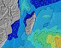 | 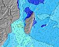 | 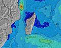 | 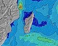 | 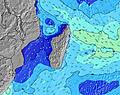 | 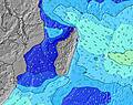 | 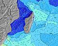 | 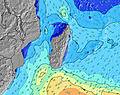 | |||||||||||||||
Wave Height (m) Direction Period (s) | SSE 9 | SW 14 | SW 13 | SW 13 | SW 13 | SW 13 | SW 13 | SW 14 | SW 12 | SW 15 | SW 14 | SW 15 | SW 15 | SW 12 | SW 15 | SW 15 | SW 14 | SW 14 | SW 14 | SW 14 | SW 13 | SW 13 | SW 13 | SW 13 |
Wave Graph | ||||||||||||||||||||||||
172 | 145 | 113 | 142 | 173 | 171 | 171 | 128 | 120 | 146 | 346 | 410 | 301 | 457 | 365 | 415 | 466 | 506 | 557 | 478 | 451 | 437 | 488 | 424 | |
Wind (km/h) | ||||||||||||||||||||||||
Wind State on-shore cross-onshore cross-shore cross-offshore off-shore glassy | glassy | cross-on | glassy | glassy | glassy | glassy | on | glassy | cross-off | glassy | glassy | glassy | glassy | glassy | glassy | glassy | glassy | glassy | glassy | glassy | glassy | cross-off | cross-off | cross-off |
High Tide | 8:15PM0.47m | 8:28AM0.42m | 9:14PM0.51m | 9:49AM0.44m | 10:04PM0.54m | 10:54AM0.47m | ||||||||||||||||||
Low Tide | 2:49AM0.24m | 2:44PM0.19m | 3:51AM0.18m | 3:47PM0.18m | 4:42AM0.11m | |||||||||||||||||||
— | — | — | 6:50 | — | — | — | — | — | — | — | 6:52 | — | — | — | — | — | — | — | 6:52 | — | — | — | — | |
— | — | — | — | — | — | — | 5:43 | — | — | — | — | — | — | — | 5:44 | — | — | — | — | — | — | — | 5:44 | |
mm | — | — | — | — | — | — | 1 | 1 | 1 | — | — | — | — | — | — | 1 | — | — | — | — | — | — | — | — |
Temp °C | 24 | 24 | 24 | 23 | 23 | 24 | 24 | 24 | 23 | 23 | 23 | 23 | 23 | 24 | 24 | 23 | 23 | 23 | 23 | 23 | 23 | 24 | 24 | 24 |
Feels °C | 26 | 26 | 26 | 25 | 25 | 26 | 25 | 27 | 25 | 25 | 26 | 26 | 26 | 26 | 27 | 26 | 26 | 26 | 26 | 25 | 25 | 26 | 26 | 26 |
Swell 1 Height (m) Direction Period (s) | SSE 9 | SSE 9 | SE 9 | SE 9 | SE 9 | SE 9 | SE 9 | SE 10 | SE 9 | SE 10 | SW 14 | SW 15 | SW 15 | SW 12 | SW 10 | SW 10 | SW 10 | SW 14 | SW 14 | SW 11 | SW 10 | SW 13 | SW 13 | SW 13 |
172 | 145 | 95 | 95 | 123 | 103 | 97 | 92 | 87 | 92 | 346 | 410 | 301 | 457 | 236 | 273 | 257 | 506 | 557 | 357 | 241 | 437 | 488 | 424 | |
Swell 2 Height (m) Direction Period (s) | SW 14 | SW 14 | SW 13 | SW 13 | SW 13 | SW 13 | SW 13 | SW 14 | SW 12 | SW 12 | SE 10 | SE 10 | SW 11 | SE 9 | SW 15 | SW 15 | SW 14 | SW 9 | SW 9 | SW 14 | SW 13 | SW 10 | SW 9 | SW 9 |
130 | 118 | 113 | 142 | 173 | 171 | 171 | 128 | 120 | 146 | 92 | 90 | 159 | 68 | 365 | 415 | 466 | 212 | 183 | 478 | 451 | 236 | 179 | 196 | |
Swell 3 Height (m) Direction Period (s) | N 4 | N 4 | N 4 | S 10 | WSW 10 | WSW 10 | NNW 5 | SW 12 | SW 15 | SW 15 | S 12 | NW 5 | SE 10 | SW 16 | SE 9 | SE 9 | SE 9 | SE 9 | SE 9 | SE 9 | SE 9 | SE 9 | SE 9 | SE 9 |
6 | 6 | 9 | 35 | 10 | 10 | 14 | 89 | 78 | 141 | 12 | 6 | 90 | 155 | 71 | 67 | 67 | 70 | 68 | 65 | 40 | 39 | 39 | 38 | |
Wind waves Height (m) Direction Period (s) | — | — | — | N 5 | N 5 | N 5 | — | NNW 5 | NNW 5 | NNW 5 | NW 5 | — | — | — | — | — | — | — | — | — | — | — | — | — |
— | — | — | 11 | 12 | 12 | — | 14 | 17 | 17 | 12 | — | — | — | — | — | — | — | — | — | — | — | — | — | |
Nearest Offshore or Glassy | ||||||||||||||||||||||||
Distance (km) | 13 | 0 | 0 | 14 | 0 | 0 | 0 | 0 | 0 | 0 | 0 | 0 | 0 | 0 | 0 | 0 | 0 | 0 | 0 | 0 | 0 | 0 | 0 | 0 |
Best forecast wave conditions in Réunion Island | ||||||||||||||||||||||||
Best forecast wave conditions in Reunion | ||||||||||||||||||||||||
Header Global | ||||||||||||||||||||||||
- Map Icons:
 Break
Break Live Wave Height (m)
 Live Wind Speed (km/h)
 Surf Rating (10 Max)
 Ocean Swells (m)
- Wind Speed (km/h)


FREE! Surf-Forecast.com widget for your website
The surf report / weather widget below is available to embed on third party websites free of charge and provides a summary of our Etang-Sale surf forecast. Simply grab the html code snippet that we provide and paste it into your own site. You can choose your preferred language and metric/imperial units for the surf forecast feed to suit users of your site. Click here to get the code.
 Nearest