
Bay of Plenty Surf Guide
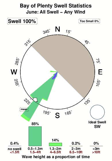
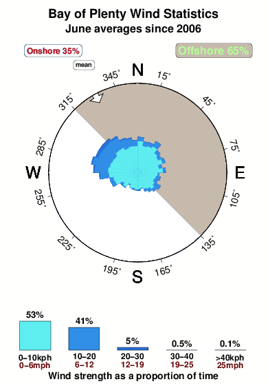
Bay of Plenty in Banyak Islands is an exposed reef break that has very consistent surf. May-Oct (Dry Season) is the best time of year for waves. Offshore winds are from the northeast. Tends to receive distant groundswells and the ideal swell direction is from the southwest. The left hand reef break is better than the right.. The quality of the surf isn't affected by the tide. Even when there are waves, it's not likley to be crowded. Rocks are a hazard.
Bay of Plenty Spot Info
| Type: | Rating: | Reliability: | Todays Sea Temp*: |
|---|---|---|---|
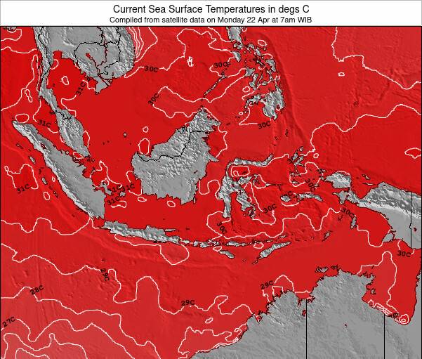
| very consistent | 30.5°C*ocean temperature recorded from satellite |
Surfing Bay of Plenty:
The best conditions reported for surf at Bay of Plenty occur when a Southwest swell combines with an offshore wind direction from the Northeast.
What's the best time of year to surf Bay of Plenty (for consistent clean waves)?
Explore Bay of Plenty Location Map
Interactive Bay of Plenty surf break location map. View information about nearby surf breaks, their wave consistency and rating compared to other spots in the region. Current swell conditions from local buoys are shown along with live wind speed and direction from nearby weather stations. Click icons on the map for more detail. The nearest passenger airport to Bay of Plenty is Binaka (Gunung Sitoli) Airport (GNS) in Indonesia, which is 108 km (67 miles) away (directly). The second closest airport to Bay of Plenty is Polonia (Medan) Airport (MES), also in Indonesia, 223 km (139 miles) away.
- Map Icons:
 Break
Break Live Wave Height (m)
 Live Wind Speed (km/h)
 Surf Rating (10 Max)
 Ocean Swells (m)
- Wind Speed (km/h)
Tuesday, 9 June 2026, 21:34 Local Time
| Tue | Wednesday 10 | |||
| 10PM | 1AM | 4AM | 7AM | |
| Wave (m) | ||||
| Period (s) | 15 | 14 | 14 | 14 |
| Wind (km/h) | ||||
| Wind State | cross- on |
cross | cross | cross |
Tides at Bay of Plenty
| NEXT | IS AT (local time) | remaining |
|---|---|---|
| high tide | ||
| low tide |
Swell History at Bay of Plenty
Surf stats for Bay of Plenty, see the swell variation by month or season on the history page here.


Wind History at Bay of Plenty
Wind stats for Bay of Plenty, see the variation in direction and stength by month or season on the history page here.
Bay of Plenty Reviews:
Interactive Porthcawl Point location map. View nearby buoy information, live wind conditions and surrounding roads, paths and locations to help find new breaks. Click the buoys or wind icon to view more information.
- Overall:
 5.0
5.0 - Quality on a good day:5.0
- Consistency of Surf:5.0
- Difficulty Level:4.5
- Wind and Kite Surfing:
 3.0
3.0 - Crowds:
 4.0
4.0
GUNTERS: Diamond shaped reef break in front of the camp
Fast breaking right hander with great potential on larger swells.probably would have a few good tube sections and may break wider and go around the corner into the bay.Works all tides with finger coral bottom..booties are a must. Fun wave at 3-4 ft down the line with few cutback possibilities.
LOLOKS : Didn't turn on when we were there however would be the power wave of the bay picking up the brunt of the swell on the head of the bay. Some nasty coral blooms in sections ...experience required.
Bottom line. This is as remote as it gets and not a place to bring partners unless they surf of course.Like any planned trip the risk is timing of swell during the stay period. it is an adventure to get there and to get decent waves would make it a lifetime memory. Tip...If the swell isn't happening in the bay forget treasures go around the back of the point and cobra logs could be firing.....left hand reef break more open to picking up the SW swell direction.”
Other Nearby Breaks Closest To:
Discover surf breaks near Bay of Plenty. Click below to view there surf guides.
 Nearest